Welcome to the fourth Automating your World column, a series of advice articles by Aptella technical experts. In this series of articles, we look at the various aspects of machine control solutions.
In the previous column, we looked at how single-antenna, twin-antenna and dual-mast GNSS (Global Navigation Satellite System – a generic term for all satellite positioning systems, including GPS)) grade control systems compared to each other and which application each was best suited for.
GNSS-based 3D grade control systems have made a major impact on how heavy construction is done, but they still have limitations when it comes to achieving very tight vertical accuracies.
This is true regardless of which brand you use.
And, while triple-constellation (GPS, GLONASS and Galileo) grade control systems will be able to work in more places and under more adverse conditions, they are still subject to the various orbital errors and environmental factors, which degrade the vertical accuracy somewhat.
Now, there are many examples of contractors who use GNSS exclusively for all their earthmoving tasks and even finishing. However, the manufacturers of these systems will tell you that they cannot guarantee the vertical accuracy will be good enough for finishing.
So, what to do?
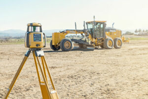
GNSS and Lasers
The various GNSS systems will give you a horizontal accuracy that is pretty much good for any earthmoving and grading task. The challenge is to find a way to improve the vertical portion of your position.
It is possible to combine the GNSS position with a terrestrial vertical reference such as a rotating laser. Such a system will use the GNSS signal to position the grader horizontally and the laser signal to get a very accurate vertical position – to within a few millimetres.
There are two ways this can be done:
1. By using a conventional, construction-grade laser
2. By using a purpose-designed, “fanned-beam” laser.
With a conventional laser, you have the benefit of being able to use the laser you already own, but you will be limited to working within a vertical range that cannot be wider than the physical length of the laser receiver you put on the grader.
What this means is that, if you have a laser receiver on the grader which is physically 1 m long, then you must keep your grader working within ±50 cm from the height at which the laser is set up.
If your grader travels further than 50cm vertically, you will lose the laser signal.
The other way to solve this is to use a fanned-beam laser
Instead of sending out a single plane of light like a standard grade laser, this laser sends out a “fanned” beam that lets the operator work to high vertical precision within a 10 m elevation range.
A fanned-beam laser will also let you use a “normal” sized laser receiver on your grader, which is far less susceptible to failure from mechanical shock and vibration.
No matter which solution you choose, a combined GNSS/laser 3D grade control system is incredibly versatile.
For most of your earthmoving tasks GNSS alone will be good enough, but when you need to tighten up your vertical, you simply pull out your laser and finish the job with that.
A strong selling point for these systems is that an unlimited number of machines can run off of a single laser. This not only lowers the cost of achieving high vertical accuracy, it also reduces the potential for set-up errors, because all machines are working from the same laser.
If you have five graders with GNSS systems already on them, you may well only have to purchase two additional laser add-ons, since they can easily be shared between all the graders.
One thing to be aware of with such a combined GNSS/laser system is that you are now faced with maintaining two lines of sight to your grader: One from the GNSS antenna to the satellites and one from the laser receiver on the grader to the rotating laser on the job site.
However, the benefits of the combined GNSS/laser system far outweighs this detail and you will find that with proper site planning and management, disruption stemming from people, other equipment, vehicles or trucks breaking the line of sight will be kept to a minimum.
Another way that 3D grade control systems achieve high vertical accuracy is to use a robotic total station as the positioning device. In fact, this is older technology than the above-mentioned GNSS/laser systems.
This system does not make use of satellite signals for positioning at all and can therefore also work indoors or in places where there is a severe obstruction of the sky, such as directly underneath an overpass or underground.
A robotic total station automatically tracks a target mounted on a mast on the blade of your grader, placed where you would otherwise mount the GNSS antenna.
Because the total station always knows where it is in the local co-ordinate system, it will also know where the target (that is, your grader) is at all times – simply by locking onto the target and following it.
The robotic total station feeds the 3D position of the target to the control box in your grader many times per second via a radio link.
These positions are then used by the onboard computer to determine cut/fill for where the blade is at a given moment, in exactly the same manner as a 3D position derived from GNSS would be used.
These systems are highly accurate and have been field-proven for more than a decade.
Although outnumbered by GNSS systems in the field, the ability to work underground and indoors will ensure that these systems will be around for a long time to come.
However, as with a combined GNSS/laser system, you must maintain clear line of sight between your grader and the robotic total station tracking it.
But, in contrast to the combined GNSS/laser system, the total station can only track a single target at a time, so this set up requires a dedicated robotic total station for each machine.
Choosing your system
The various positioning technologies available for 3D grade control systems today have all come about because they each solve a particular problem and are particularly well suited for a specific application.
It is unlikely that a single positioning technology will solve all the earthmoving and grading tasks faced by your company, so it is important that you stay educated about the various solutions currently available.
For many contractors, the ease with which various sensor technologies can be switched around is paramount – so ensure you speak to your positioning system sales representatives to ensure you have the maximum flexibility from whatever solution you choose.
Something else to look for is a consistent operator interface between different positioning technology, so the operator screen remains unchanged and familiar no matter which type of positioning is currently being used.
That means shorter learning curves, and the ability for operators to very quickly switch from one type of system to another.
Speak to your sales representative not only about which system is right for your particular job, but which systems are right for your company across your full range of work and projects.
Advanced technology is great, but it is essential it be combined with competent and timely local support in order to be of most value to you, and to help you sort out problems and issues.
Grade well, grade quickly.