Cohen & Associates is a Tasmanian survey company with a core business of land surveying, including cadastral and engineering projects. Recently, the company has invested in state-of-the-art Unmanned Aerial System (UAS) technology and is pushing the boundaries in near-infrared and aerial mapping for the agriculture industry.
Adrian Fairfield is a Director of the company and a registered land surveyor. He explains that his team’s prior experience with remote sensing applications using satellite-based and manned aircraft led them to explore the possibilities of saving time and increasing efficiency with an unmanned solution.
“Over the years, we’ve developed unique processes for remote sensing applications using satellite-based and manned aircraft,” he said. “These had their limitations, however, as you needed to wait for the satellite to be in the correct position and manned flights were both weather-dependent and had to be scheduled in advance.
“I could see the advantages a UAV system would have over these methods, as they enable rapid data capture with the ability to launch a project immediately and deliver high quality results,” he added.
The right solution
After some online research and product comparisons, Mr Fairfield attended a demonstration of the SIRIUS Pro UAV in Adelaide, hosted by Australasian distributor, Aptella.
“I was impressed with the in-flight stability of the SIRIUS Pro, its long flight time capability and the unique ability to achieve five-centimetre accuracy without the need to set out extensive ground control points,” he explained.
The SIRIUS Pro UAV by MAVinci is a fixed-wing remotely piloted aircraft that utilises high precision GNSS positioning to achieve five centimetre accuracy without the need to set out ground control points. Through a combination of an on-board GNSS receiver and ground-based GNSS antenna, the SIRIUS Pro effectively puts the ground control points in the air automatically, eliminating the need to physically set them out on the ground.
“Another key factor in our decision-making process was having local support from the supplier, which we receive from Aptella,” Mr Fairfield added.
“We like to push new technology to its limits, really delve into it and customise it to our needs and unique applications, so having the support of Aptella along with the research and development team at MAVinci in Germany has been terrific. They are always quick to respond and assist us, MAVinci has also been helping to customise some of its software to accommodate our needs.”
Going through the regulatory process to become a certified UAS pilot was a challenge, Mr Fairfield says, but an important one. “Gaining our certification was a lengthy and detailed process, but as you go through it you realise how critical it is to be able to deploy these systems safely and proficiently,” he said.
“I understand that now the process is becoming more straightforward, but when we did it CASA (Civil Aviation Safety Authority) was still finalising a lot of the regulations, so it took a little longer. We had great support from both Aptella and CASA to help us with our certification and training, and we have two accredited pilots now in our team,” he added.
Pushing the boundaries
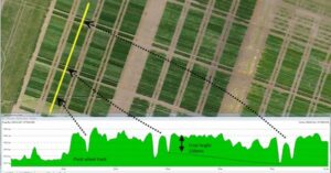
Cohen & Associates has completed many projects and testing with the SIRIUS Pro UAV. The company has experienced great success with precision farming applications, having undertaken a number of projects that involve the use of near infrared technology for crop monitoring and yield mapping.
“We have been experimenting with a number of unique applications, including breakthroughs with weed and crop health mapping to support better management practices,” he said.
“Unlike manned flyovers, UAS technology offers access to highly detailed data in a very short time period, which is important in precision farming as you need to take action quickly based on the results. If you have to wait for weeks or even days for the outputs to come through, it’s already too late to make critical management decisions.”
Mr Fairfield explains that the use of near infrared technology and aerial mapping enables agriculture specialists and farmers to accurately analyse their crops and link this data in with yield mapping information.
“Farmers can compare their yields with the mapping information we provide and prove there has been an improvement,” he said.
“We feel there is a lot of potential in this area and we’ve been working with MAVinci to establish procedures that deliver early results from a flight before you even leave the paddock. That is very powerful information for an agriculture specialist to have, they can take action based on initial results right away and fine tune it when the more detailed data analysis has been completed,” he added.
Realising the potential
In addition to precision farming applications, Cohen & Associates has also deployed UAS technology for stockpile, quarry, landfill and coastal projects. “The safety and efficiency benefits in applications like these are enormous – UAS enables us to survey areas that are too hazardous or inaccessible to survey using traditional methods,” Mr Fairfield said.
“There are so many applications that UAS technology is well suited to, and we can adjust the accuracy of the results depending on the job,” he added. “We can easily achieve 2-5 centimetre accuracy when we need to with the SIRIUS Pro, but not every application calls for that level.”
Mr Fairfield said that he’s impressed with the turnaround time they are able to offer to clients on projects. “Being able to provide such a detailed data set in a single day as opposed to weeks is a fantastic benefit of this technology. We are also pleased to have a system that enables us to customise solutions and push the boundaries, with the support we receive from Aptella and MAVinci,” he said.