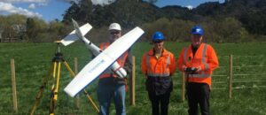
Fulton Hogan, an international civil construction company specialising in transport, energy, mining and infrastructure projects, recently updated the firm’s project surveying methods in New Zealand by investing in a Remotely Piloted Aircraft System (RPAS).
Fulton Hogan & HEB Alliance is a joint venture project on the Huntly Bypass, a continuation of the Waikato expressway in between Auckland and Hamilton. This $458 million dollar project is set to transform the 15.2 kilometre stretch of the Waikato Expressway between Ohinewai and Ngaruawahia, between Auckland and Hamilton. Construction began in 2015 with the expressway due to be completed by 2019-2020.
Innovative Solutions
With such a large scale project at hand Fulton Hogan decided to look into new efficient ways to manage the survey aspect of the project.
“We were finding that conducting monthly survey measurements on large earthwork sites using traditional optical and GNSS survey methods were costly and involved out-sourcing the job to contractors,” said Ed Kelly, Fulton Hogan’s Survey Manager for the project. “So we decided to look at what else the market could offer to save time and money and increase safety,” he added.
After researching the various RPAS solutions available on the market, Ed met with Jamie Nelson, Aptella New Zealand Sales Manager, who offered the perfect solution.
“When Jamie showed me the Sirius Pro with the RTK unit I knew I had found what I was looking for,” Ed said.
Most RPAS solutions require the use of a series of ground control points to give reference locations for the images taken during a flight, so the photos can be collated into an orthophoto and subsequently a 3D model during post processing.
The Sirius Pro, however, uses a combination of on-board and ground-based GNSS technology to eliminate the need for ground control points, saving time and removing the dangers associated with surveyors working on hazardous terrain and near active machinery. Another very useful feature is the Terrain compensation in the flight panning Mavinci Desktop software. This allows the Sirius to maintain an even GSD (Ground sampling distance) for consistent and accurate results in mountainous terrain.
“For a large road development project such as this, the use of ground control would add considerable time and expense to the end of month surveys, negating many of the benefits of this new technology,” Ed explained. “But I knew when I saw the Sirius Pro that it had the potential to drastically improve our workflow and offer a far more efficient, accurate and cost effective option.”
To make sure the Sirius Pro was up to the task and could deliver the results Fulton Hogan required, Ed undertook a series of test flights with the system. “There is always a degree of caution when investing in new technology as the results need to be proven, but when I saw the data produced from our trial flights, I was really impressed and knew it was the right tool for the job,” he added.
A good return on investment
Since introducing RPAS technology Fulton Hogan has observed major time and cost savings on survey work for the Huntly Bypass Project.
“Previously, we would contract four surveyors for a week each month to conduct an end of month survey. While the surveyors were collecting their data we would shut down sections of the site as it’s not safe to have anyone working near live machinery, but that of course has a knock-on effect to productivity and project costs.
Now with the RPAS solution we can conduct the end of month surveys with two people in just 2-3 days. There is no need for the surveyors to work near machinery, which means there is no construction down time and the site is a lot safer overall.” Ed said.
Time savings and safety improvements have been a bonus to the Huntley Bypass survey team but they were also impressed by the quality of the RPAS data produced.
“I was surprised that the RPAS can produce higher quality data than traditional survey methods – I thought that at best it would match it, but never did I expect it to be better,” Ed explained.
Diversification of use – added bonus
Although purchased specifically for end of month surveys, Ed’s team is now using the Sirius Pro on a number of other tasks because of its ease of use and the high quality data it produces.
“We now use the Sirius for jobs such as earthwork surveys and tree clearing – it’s probably used 2-3 times per week for survey work on site,” he said. “It’s proved a great return on investment.”
Support & Training
Prior to using the Sirius Pro on site, Ed and his team attended two RPAS operator training courses, provided by Aptella Campus in conjunction with Massey University – School of Aviation.
“I am really happy with the training and support we have received form Jamie and the Aptella team,” Mr Kelly said. “On-boarding with any new technology has its challenges and they have been on-hand throughout to ensure everything ran smoothly.”
Overall, Ed feels the introduction of the RPAS has been a great success.
“The Sirius has made a huge difference to our job and the productivity benefits have been noticed throughout the business. I certainly recommend this solution to colleagues and peers for a safer and more efficient way to survey, particularly on larger projects,” he added.