Fyfe implements MiRTK when working in highly vegetated and hilly areas

Search

Lauren Baguley, Surveyor, Fyfe was looking for an alternative to UHF when working in the highly vegetated and hilly regions, particularly in the Pilliga Forest near Narrabri, when she was introduced to MiRTK internet enabled corrections from Aptella by a colleague.

Ms Baguley and her team focuses on surveying and aerial mapping within the agricultural, construction and mining industries for the Narrabri area.

“We do struggle with UHF when we’re out in the scrubby country around here, it’s quite hilly. Where there’s a lot of vegetation, sometimes we can’t even get a kilometre away from the base so there’s a lot of leap frogging going on and having to set up the base multiple times is painful when you’re trying to get a job done,” explained Ms Baguley.

MiRTK solves difficulty when working in heavily vegetated and hilly areas

MiRTK has been the ideal solution for the difficulty that Ms Baguley and her team faces using UHF when working in heavily vegetated or hilly areas or when working too far away from a CORS base to maintain accuracy.

Because MiRTK sends GNSS correction signals between the base station and rover devices via the Internet, the service eliminates the need to rely on UHF radios and repeaters. MiRTK does not require line of sight between the rover and base unit, enabling users to work over large areas and in the most challenging landscapes without experiencing interference or black spots. If users have enough mobile signal to send and receive an email on their smartphone, MiRTK will work seamlessly without distance from base limitations that you experience with UHF radios.

Mirtk UHF correction services

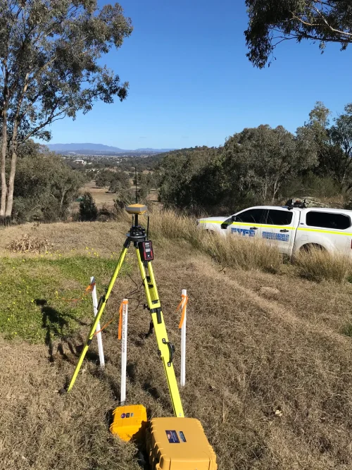
“I was really excited to try MiRTK out, especially when we’re out in the Pilliga,” said Ms Baguley.  

“MiRTK is absolutely perfect, we’ve got just enough service out there and we have this one base station that’s up on a high bank, we just set it up there, put MiRTK on it and we can pretty much get everywhere we need to get out in the Pilliga.”

MiRTK saves time for surveyors

One of the main benefits that Ms Baguley has found since implementing MiRTK is the time savings. Previously, when Fyfe was using UHF in those heavily vegetated and hilly areas, the team would need to move the base quite frequently and would have to spend a lot of wasted time, not only moving the base but trying to figure out where to put it next.

“When you have to re-set up the base every time you move, it just takes up so much time, so with MiRTK we’re able to get a lot more work done in a day,” said Ms Baguley.

“With MiRTK I just set up one base for the day and I’m done! It’s perfect. It’s so much better when you can find something that can remove all that wasted time,”

MiRTK works seamlessly with old and new GNSS technology

MiRTK is a brand agnostic solution, meaning that it works with all makes, models and ages of GNSS equipment. This can be particularly useful for large project sites, with multiple systems working on a single base station. MiRTK has no licence limitations either, with up to 10 connections on a single licence and unlimited capacity to increase connections as required.

Ms Baguley has found that MiRTK works seamlessly with both the new Topcon base and rover kits the team is using, as well as the Javad base and rover kit that the team has used for over a decade. 

“I’ve found that MiRTK works seamlessly with my GNSS equipment, it’s very easy to use,” said Ms Baguley.

“We mainly use Topcon now, we’ve got all new base and rovers, but it’s still compatible with the old stuff as well. We’ve got a very old Javad base and rover kit that we only use now as a back-up, we’ve had it for about 11-12 years and even that old one worked perfectly with MiRTK!”

MiRTK easy to set up and use but support still necessary

According to Ms Baguley, it’s important to take into consideration the service and support available when making a new technology purchase. Even thought the team hasn’t required any support to integrate MiRTK into their workflow, Ms Baguley notes it’s important to have that back-up support available.

“We haven’t needed to reach out to Aptella with MiRTK, it was very straight forward and easy to set up ourselves,” said Ms Baguley.

“However, you’ve always got to have someone there that knows what’s going on with new technology. It’s handy to make a phone call and get the support you need.”

Ms Baguley would recommend any surveyors working in heavily vegetated and hilly areas test out using MiRTK internet enabled corrections: “With MiRTK we don’t have to worry about the hills and the trees anymore like we had to with the UHF connection. Whenever I’ve used it, it hasn’t skipped a beat.”

About Fyfe

Fyfe is a fully integrated engineering, environment, planning and survey firm, employing 300 staff across major capital cities and regional centres in Australia.

Leave a Reply

Your email address will not be published. Required fields are marked *