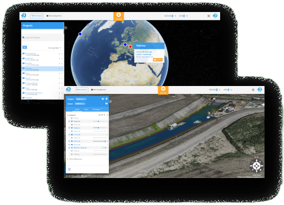
Live, secure web-based platform to view and analyse your 3D and 4D data sets.
Fusion and layering of data over time helps you track the project as it develops. Collaborate with colleagues, clients and other stakeholders in an intuitive and easy to navigate browser.
One platform to connect and control your geospatial world, increase efficiencies and expand your capabilities. 4DMapper is a collaborative framework to control your digital assets, processes and workflows, on the cloud or within your network. Built-in tools for reality modelling, asset inspection, virtual surveying and geospatial analytics. Control, collaborate, process, analyze, integrate and deliver. Advanced SDK and REST API to develop your custom platform
[av_icongrid icongrid_styling=’flipbox’ icongrid_numrow=’3′ icongrid_borders=’none’ icongrid_padding=” icongrid_padding_sync=’true’ custom_title_size=” custom_subtitle_size=” custom_content_size=” custom_icon_size=” font_color=’custom’ custom_icon=’#f89828′ custom_title=” custom_subtitle=” custom_content=” bg_color=” custom_front_bg_type=’bg_color’ custom_front_bg=” custom_front_gradient_color1=” custom_front_gradient_color2=” custom_front_gradient_direction=’vertical’ custom_back_bg_type=’bg_color’ custom_back_bg=” custom_back_gradient_color1=” custom_back_gradient_color2=” custom_back_gradient_direction=’vertical’ custom_tooltip_border=” grid_color=” custom_grid=” av-medium-font-size-title=” av-small-font-size-title=” av-mini-font-size-title=” av-medium-font-size=” av-small-font-size=” av-mini-font-size=” av_uid=’av-228lwj6′ custom_class=”]
[av_icongrid_item title=’Control’ link=” linktarget=” subtitle=’Control where your data is, who can work on it and what they can do with it. ‘ icon=’ue826′ font=’entypo-fontello’ item_font_color=” item_custom_icon=” item_custom_title=” item_custom_subtitle=” item_custom_content=” item_bg_color=” item_custom_front_bg_type=’bg_color’ item_custom_front_bg=” item_custom_front_gradient_color1=” item_custom_front_gradient_color2=” item_custom_front_gradient_direction=’vertical’ item_custom_back_bg_type=’bg_color’ item_custom_back_bg=” item_custom_back_gradient_color1=” item_custom_back_gradient_color2=” item_custom_back_gradient_direction=’vertical’ item_custom_tooltip_border=” av_uid=’av-1nsjrma’]
Don’t commit your data to someone else’s silo. Keep it secure on the cloud or in your network.
[/av_icongrid_item]
[av_icongrid_item title=’Collaborate’ link=” linktarget=” subtitle=’A 3D/4D web browser based workspace, sophisticated in function but intuitive to use’ icon=’ue83c’ font=’entypo-fontello’ item_font_color=” item_custom_icon=’#f89828′ item_custom_title=” item_custom_subtitle=” item_custom_content=” item_bg_color=” item_custom_front_bg_type=’bg_color’ item_custom_front_bg=” item_custom_front_gradient_color1=” item_custom_front_gradient_color2=” item_custom_front_gradient_direction=’vertical’ item_custom_back_bg_type=’bg_color’ item_custom_back_bg=” item_custom_back_gradient_color1=” item_custom_back_gradient_color2=” item_custom_back_gradient_direction=’vertical’ item_custom_tooltip_border=” av_uid=’av-1btsng2′]
Manage, visualise, analyse and deliver your geospatial, GIS and BIM data without software and high-spec computers. Share the data with everyone that needs it in an interface that’s easy to use and navigate.
[/av_icongrid_item]
[av_icongrid_item title=’Connect’ link=” linktarget=” subtitle=’Integrate your software or hardware solutions’ icon=’ue822′ font=’entypo-fontello’ item_font_color=” item_custom_icon=’#f89828′ item_custom_title=” item_custom_subtitle=” item_custom_content=” item_bg_color=” item_custom_front_bg_type=’bg_color’ item_custom_front_bg=” item_custom_front_gradient_color1=” item_custom_front_gradient_color2=” item_custom_front_gradient_direction=’vertical’ item_custom_back_bg_type=’bg_color’ item_custom_back_bg=” item_custom_back_gradient_color1=” item_custom_back_gradient_color2=” item_custom_back_gradient_direction=’vertical’ item_custom_tooltip_border=” av_uid=’av-30g8du’]
Connect your custom applications. Get the most out of your existing local resources and centralise your workflows.
[/av_icongrid_item]
[/av_icongrid]
[av_icongrid icongrid_styling=’flipbox’ icongrid_numrow=’3′ icongrid_borders=’none’ icongrid_padding=” icongrid_padding_sync=’true’ custom_title_size=” custom_subtitle_size=” custom_content_size=” custom_icon_size=” font_color=” custom_icon=” custom_title=” custom_subtitle=” custom_content=” bg_color=” custom_front_bg_type=’bg_color’ custom_front_bg=” custom_front_gradient_color1=” custom_front_gradient_color2=” custom_front_gradient_direction=’vertical’ custom_back_bg_type=’bg_color’ custom_back_bg=” custom_back_gradient_color1=” custom_back_gradient_color2=” custom_back_gradient_direction=’vertical’ custom_tooltip_border=” grid_color=” custom_grid=” av-medium-font-size-title=” av-small-font-size-title=” av-mini-font-size-title=” av-medium-font-size=” av-small-font-size=” av-mini-font-size=” av_uid=’av-74p60i’ custom_class=”]
[av_icongrid_item title=’Your Teams’ link=” linktarget=” subtitle=” icon=’ue80b’ font=’entypo-fontello’ item_font_color=’custom’ item_custom_icon=’#f89828′ item_custom_title=” item_custom_subtitle=” item_custom_content=” item_bg_color=” item_custom_front_bg_type=’bg_color’ item_custom_front_bg=” item_custom_front_gradient_color1=” item_custom_front_gradient_color2=” item_custom_front_gradient_direction=’vertical’ item_custom_back_bg_type=’bg_color’ item_custom_back_bg=” item_custom_back_gradient_color1=” item_custom_back_gradient_color2=” item_custom_back_gradient_direction=’vertical’ item_custom_tooltip_border=” av_uid=’av-1msrm5u’]
Users, Access Privileges, Controls,
Sharing, Delivery Collaboration, Internal & External.
[/av_icongrid_item]
[av_icongrid_item title=’Your Data’ link=” linktarget=” subtitle=” icon=’ue84b’ font=’entypo-fontello’ item_font_color=’custom’ item_custom_icon=’#f89828′ item_custom_title=” item_custom_subtitle=” item_custom_content=” item_bg_color=” item_custom_front_bg_type=’bg_color’ item_custom_front_bg=” item_custom_front_gradient_color1=” item_custom_front_gradient_color2=” item_custom_front_gradient_direction=’vertical’ item_custom_back_bg_type=’bg_color’ item_custom_back_bg=” item_custom_back_gradient_color1=” item_custom_back_gradient_color2=” item_custom_back_gradient_direction=’vertical’ item_custom_tooltip_border=” av_uid=’av-17h9sia’]
Satellite, Aerial, Drone, Terrestrial,
Imagery, DTMs, Pointcloud, Mesh models, Photo, CAD, BIM, GIS
[/av_icongrid_item]
[av_icongrid_item title=’Your Processes’ link=” linktarget=” subtitle=” icon=’ue855′ font=’entypo-fontello’ item_font_color=’custom’ item_custom_icon=’#f89828′ item_custom_title=” item_custom_subtitle=” item_custom_content=” item_bg_color=” item_custom_front_bg_type=’bg_color’ item_custom_front_bg=” item_custom_front_gradient_color1=” item_custom_front_gradient_color2=” item_custom_front_gradient_direction=’vertical’ item_custom_back_bg_type=’bg_color’ item_custom_back_bg=” item_custom_back_gradient_color1=” item_custom_back_gradient_color2=” item_custom_back_gradient_direction=’vertical’ item_custom_tooltip_border=” av_uid=’av-i8wquq’]
GIS, Photogrammetry, Databases, AI, Custom apps, Dedicated storage
[/av_icongrid_item]
[/av_icongrid]
[av_one_half first av_uid=’av-13c6umq’]
Jump on the 4DMapper Cloud product now to try out the built in features. But don’t stop there. 4DMapper is designed to work in your environment, bringing your processes and services to life. The 4DMapper SaaS product is just an example of what you can build with our APIs and SDK.[/av_one_half][av_one_fourth first av_uid=’av-3qb8ub6′]
[av_font_icon icon=’ue848′ font=’entypo-fontello’ style=” caption=” link=” linktarget=” size=’50px’ position=’center’ animation=” color=’#f89828′ av_uid=’av-3atutrm’ custom_class=” admin_preview_bg=”]
Automated 3D data tiling and streaming in open-standard web formats in a live, collaborative, browser-based environment. Fast, with no data loss and no size limits. Deliver massive geodata to end-users immediately, with visualization and collaboration. Engage your wider team, clients and stakeholders with live access.
[/av_font_icon]
[/av_one_fourth]
[av_one_fourth av_uid=’av-32pck9e’]
[av_font_icon icon=’ue84b’ font=’entypo-fontello’ style=” caption=” link=” linktarget=” size=’50px’ position=’center’ animation=” color=’#f89828′ av_uid=’av-2o16xiq’ custom_class=” admin_preview_bg=”]
Seamless access to high resolution (0.7m to 3m) satellite imagery collected daily, weekly and monthly, anywhere in the world. Precisely geo-located remote site monitoring and surveillance with an option to generate 0.7m resolution 3D terrain models of any remote location.
[/av_font_icon]
[/av_one_fourth]
[av_one_fourth av_uid=’av-222ppn6′]
[av_font_icon icon=’ue80f’ font=’entypo-fontello’ style=” caption=” link=” linktarget=” size=’50px’ position=’center’ animation=” color=’#f89828′ av_uid=’av-1mc5mdu’ custom_class=” admin_preview_bg=”]
A great example of an external application connection to turn drone photos into actionable 3D models and point-clouds, right in your web browser. No high-end processing computer or software licensing required. Retain full control over processing, import image coordinates, mark control points, set projections and generate survey reports.
[/av_font_icon]
[/av_one_fourth]
[av_one_fourth av_uid=’av-12sjjo2′]
[av_font_icon icon=’ue826′ font=’entypo-fontello’ style=” caption=” link=” linktarget=” size=’50px’ position=’center’ animation=” color=’#f89828′ av_uid=’av-2p2uqa’ custom_class=” admin_preview_bg=”]
Inspect and tag 3D virtual assets with interactive photo targeting. Link annotations, reports, photos and videos to a location on your asset or connect to external attribute databases. Generate reports and automate your workflow in a live, collaborative, access-controlled environment.
[/av_font_icon]
[/av_one_fourth]
[av_one_third first av_uid=’av-3337ynm’]
[av_font_icon icon=’ue8c7′ font=’entypo-fontello’ style=” caption=” link=” linktarget=” size=’50px’ position=’center’ animation=” color=’#f89828′ av_uid=’av-2iz0aeq’ custom_class=” admin_preview_bg=”]
Measure and digitize collaboratively in a real-time virtual 3D environment. Extract points, lines and areas and export in standard format. Calculate volumes using multiple computation algorithms. Compare volumes between terrain models or with design files to colorize change and measure precise cut and fill. Create colorized elevation model, analyze slope and create dynamic contours.
[/av_font_icon]
[/av_one_third]
[av_one_third av_uid=’av-23e83pu’]
[av_font_icon icon=’ue812′ font=’entypo-fontello’ style=” caption=” link=” linktarget=” size=’50px’ position=’center’ animation=” color=’#f89828′ av_uid=’av-69bmfm’ custom_class=” admin_preview_bg=”]
Automatically filter pointclouds from LiDAR or photogrammetry data processing. Classify objects, remove unwanted features and extract bare-earth model. Measure and digitize features, markup in 3D with annotation, connect your own analytics toolkit, create snapshots and fly-through paths. Identify and mitigate potential risks. All in your browser, without multiple software packages or high-end hardware requirements.
[/av_font_icon]
[/av_one_third]
[av_one_third av_uid=’av-14o23o2′]
[av_font_icon icon=’ue855′ font=’entypo-fontello’ style=” caption=” link=” linktarget=” size=’50px’ position=’center’ animation=” color=’#f89828′ av_uid=’av-t71pbm’ custom_class=” admin_preview_bg=”]
Comprehensive RESTful APIs to integrate with your application (desktop or cloud) and automate workflows using secure HTTP requests in any framework. Full control to access 4DMapper back-end via your application, upload and tile data, download, delete, manage access control, manage users and etc.
[/av_font_icon]
[/av_one_third]
We source, deploy and support intelligent positioning solutions to enhance our customers’ productivity.
Aptella Ltd
NZBN 942 904 109 4730
2024 Aptella Ltd | NZBN 942 904 109 4730 | Terms and Conditions | Privacy Policy
Reviews
There are no reviews yet.