
Pix4D image processing software is a complete mapping and modelling solution which can transform thousands of images into geo-referenced 2D mosaics and 3D models. Pix4Dmapper automatically processes terrestrial and aerial imagery taken by light-weight drone using innovative technology based on image content. Using the software the images can be converted into high precision, customisable results which can be used on a wide range of GIS and CAD applications.
The software includes integrated editing tools such as:
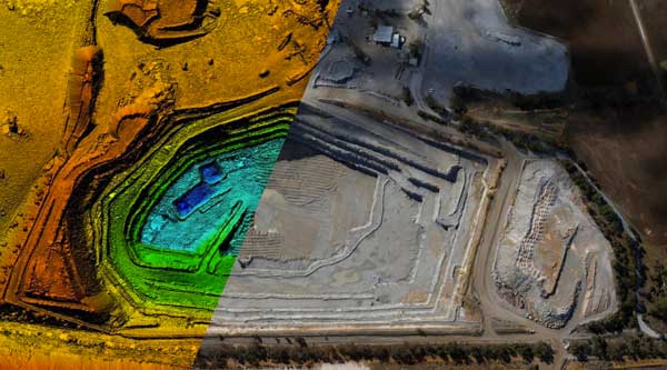
Mines and Quarries – Technology enables the management of extraction activities and environmental protection issues in a cost-effective way. Compared to traditional surveying methods, using UAVs and the Pix4Dmapper increases safety, efficiency and accuracy, while keeping cost and labour to a minimum. The Pix4D technology enables the production of orthomosaics, DSMs, DTMs and point clouds of quarries and pits to calculate volumes of extracted materials, stockpile volumes and monitor site hot-spots.
Agriculture – Pix4Dmapper enables continuous land management and environmental protection at a competitive cost through the creation of maps from any multi-spectral sensor. Create index maps; DVI, NDVI, SAVI and export created index maps as GeoTIFFs and Shapefile into AG software.
Emergency Response – Pix4Dmapper provides fully automatic workflows required to create accurate maps required for effective emergency response. Unlike satellite imagery, orthomosaics and digital surface models produced by Pix4Dmapper can be created immediately after the flight, in all weather conditions.
Natural Resources – Pix4Dmapper enables the creation of extensive natural resource inventories, the ability to manage environmental regulations and assess vegetation cover. Output results such as orthomosaics, DSMs, DTMs and contour lines will integrate seamlessly into existing GIS software.
Construction – the Pix4D application enables 4D construction site monitoring to suit individual site needs. Create survey grade orthomosaics, DSMs and dense 3D point clouds instantly using Pix4Dmapper’s automatic workflow and repeat the process in fixed time intervals and analyse results over time to monitor contractors and construction advancements.
Archaeology – Pix4D can produce outputs to assist archaeologists to identify archaeological features, generate topographic GIS data to support archaeological surveying and subsequent phases of excavation.
[av_one_third first]

Bridge the gap between photogrammetry and CAD
[/av_one_third][av_one_third]
![]()
Next-generation photogrammetry software for terrestrial, corridor and large scale mapping
[/av_one_third][av_one_third]

The online platform for drone mapping, progress tracking, and site documentation
[/av_one_third]
Contact us to book a training session with our Pix4D Experts.
Reviews
There are no reviews yet.