Description
New Compact, Powerful 3D Scanning Technology
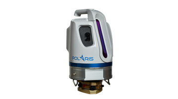
The Polaris Terrestrial Laser Scanner delivers accurate, precise data faster than ever before, bridging the gap between small, light-weight, short-range sensors and large, long-range, pulsed time-of-flight scanners. Built with surveyors in mind, the Polaris has a user-friendly on-board operator interface with menu-driven operations for quickly collecting and referencing data.
With an integrated high-resolution camera, inclinometers, a compass, a GPS receiver, and weather-proof housing, the Polaris can be deployed in many environments and orientations. The Polaris leads the market in price versus performance, starting at a price that rivals short-range scanners while outperforming most long-range scanners. With accelerated performance and all the built-in features surveyors need, a single Polaris executes more applications than ever before. Whether on a tripod, vehicle, or moving platform, the outstanding performance of the Polaris makes it the most versatile terrestrial laser scanner on the market.
Applications
- Civil Engineering
- Construction
- Transportation
- Heritage
- Mining
- Forensics
- Forestry
- Scientific Research
Features
- Long-range capability
- High-speed data acquisition
- 100% scanner effi ciency
- Wide, selectable fi eld of view
- Internal data storage
- Internal camera
- External camera option
- Weather-proof housing
- Automatic target recognition
- User-friendly workfl ow
- Automatic target-free registration
- Project planner
- Multiple lidar returns
- Tilt compensation
- GPS receiver
- Compass
- Laser plummet
- Easy upgrade

Reviews
There are no reviews yet.