Aptella, Australia’s largest retailer of positioning and geospatial solutions for surveying, mining and civil construction, have partnered with Klau Geomatics to bring the Klau PPK High Precision Drone module to the Australian market.
Aptella provides the industry’s leading support for geospatial professionals with dedicated support centres across the country. Klau Geomatics is an innovative Australian technology company that produces one of the most accurate, compact and sophisticated aerial geo-positioning solutions for high precision mapping and inspection.
 The uptake of drone technology in construction, mining and inspection has put photogrammetry front and centre as the required skillset for the industry. There is a large gap here in knowledge and experience, that Aptella has filled by establishing themselves as the industry’s leading support source for geospatial professionals.
“We’ve been working with the Klau Geomatics team for a couple of years now and have seen this product develop to the sophisticated solution we see today,” says Martin Nix, CEO of Aptella. “We have solid product adoption with many of our enterprise customers across the mining and construction sectors.”
“Aptella are the right choice to take our product to market, with skilled surveyors as their sales and support staff.” says Rob Klau, Director of Klau Geomatics. “Support is critical to our customers. The Klau PPK system is more than just a drone payload, it’s survey equipment. When we get into handling custom coordinate systems, site localisation and details of photogrammetry, the level of support many customers need starts to grow. With Aptella’ reach on sales and support we can focus on what we do best, continuing to develop an industry leading product.”
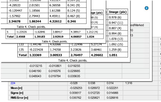
Customers are routinely achieving absolute positioning results at the 3cm level XYZ on the ground using the Klau-calibrated camera supplied with the Klau PPK kits for DJI drones. The time saving both in the field (no need to place GCPs) and in the office (reduced photogrammetry processing time), with the streamlined workflow for data processing and management, makes this a very valuable product for survey professionals.
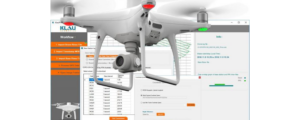
With the seamless integration of the Klau PPK unit onto almost any drone, including the DJI Phantom 4 Pro, Matrice 200 and M600, no professional operator should be without this high precision option for their drone.
“Aptella are very proud to be the exclusive distributor of this revolutionary airborne survey product and are looking forward to improving productivity for our existing and new customers” says Gavin Docherty RPAS product Manager at Aptella. “The high quality of the L1/L2 GNSS receiver (BeiDdou enabled), coupled with tight integration to Position Partner’s AllDayRTK CORS network, means the end user has all the tools necessary to carry out reliable Aerial surveys efficiently and without the need for ground control across the coverage area.”
 |
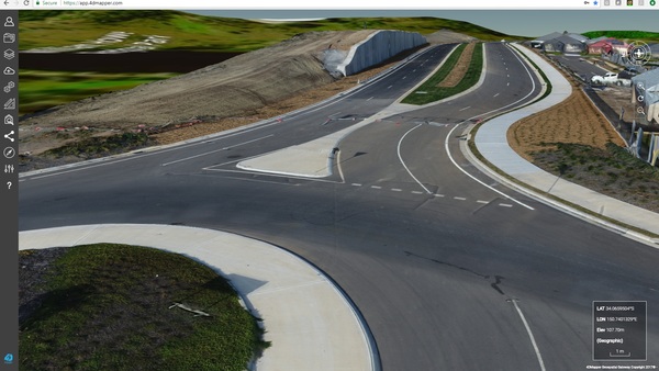 |
| Multiple survey reports showing absolute accuracy achievable (sub-5cm) | 3D model of a precise RPAS case study in NSW |
Luke Burton
Principal Surveyor
BHP Billiton Mining, AU
27 June 2018
Thanks for giving me the opportunity to participate, my experience has been great.
What results have you gotten from our product, in regards to accuracy?
After conducting numerous missions of trial areas, as well as comparisons to physical GPS/laser scanning surveys I have observed the following accuracies:
What made you believe that Klau Geomatics was the best choice for achieving your desired results?
We compared multiple products and ended up down the path of PPK, this left 2 products on the market. We already had one of the other products, so was in our best interest to trial the KLAU system. Ultimately the results were favourable for KLAU, hence our subsequent orders. The difference came down to:
What exactly do you like most about our product?
As above, however excellent support, accurate. Physical modification and calibration of the camera to get the exact timing.
If a potential client was on the fence about whether to purchase from Klau Geomatics, what would you say to them?
We have found the accuracy to be excellent, based on our flight settings and subsequent processing in Agisoft. The support received from KLAU team has proven superb and helped with implementation of the product. Physically tapping the shutter on the camera removes a large source of error that other products only compensate for.
Michael Cutfield
Survey Manger
The Fletcher Construction Company Ltd, NZ
26 June 2018
What results have you gotten from our product, in regards to accuracy?
The accuracy of the Klau PPK Module exceeds expectations every time. I have performed some checks using a surveyor’s Total Station against the results from the Klau PPK Module, and if the flight is done at low altitude and with a large overlap, the accuracy on any point is as good as single measurement performed by RTK GNSS measurements (usually better than 20mm).
What made you believe that Klau Geomatics was the best choice for achieving your desired results?
After an experience with a competing system, I needed to be sure that Klau Geomatics was going to deliver the system that was offered. After speaking with Rob Klau many times, I could tell that he and his company were very capable of delivering, as well as being always available to provide support and answer any questions.
What exactly do you like most about our product?
I love the fact that it just works… every time. Oh, and not spending hours/days placing ground control points too, of course.
If a potential client was on the fence about whether to purchase from Klau Geomatics, what would you say to them?
The support is second to none. And the cost benefit of not placing GCPs will pay for itself very quickly. Not to mention the added safety and freedom of not needing to walk the subject site. It’s a no brainier.
Will Heesterman
Surveyor
The Surveying Company HB Ltd, NZ
26 April 2018
Basically this PPK unit is awesome.
What results have you gotten from our product, in regards to accuracy?
Most errors come in at around 20mm horizontally and 30mm vertically. The worst result I have achieved is 49mm vertically on a check point, and 33mm horizontally. This is well within spec for the work we do with the UAV.
What made you believe that Klau Geomatics was the best choice for achieving your desired results?
I read numerous articles on PPK vs RTK, and PPK appeared to be the better option for many reasons. I started researching PPK units for UAV’s, and found the Klau unit. I then spoke to Rob a few times about how it all worked etc and he was extremely helpful. Being able to speak directly to the company and ask questions was a big plus. And that support has been ongoing, even after purchasing the unit.
What exactly do you like most about our product?
The best thing about this unit is that it allows you to survey areas that are inaccessible without having to lay ground control. The time saved by not having to drive all over the survey area putting out ground control is huge. The unit is also very small and doesn’t seem to have an effect on flight times, and the post flight reduction software is pretty straight forward to use.
If a potential client was on the fence about whether to purchase from Klau Geomatics, what would you say to them?
Give Rob a call and have a chat. Then just buy one!