“The only thing that is constant is change” Heraclitus of Ephesus c. 535 BC-475BC
As with recent advances in the fields of biotechnology, materials sciences and computing, the advent of new technologies in the field of geospatial engineering have the ability to radically reshape nearly every facet of human endeavour, creating opportunities for new jobs, new industries and new economies.
The ability to integrate satellite and land based navigation positioning systems with three (3) dimensional computer models, real time communication networks and laser and inertial guidance technologies has underpinned a paradigm shift across multiple industries that has been described as the biggest change since the Industrial Revolution. (Caterpillar, 2006)
Since its initial development for strictly military purposes, the Global Positioning System (GPS) has been, (particularly since the early 2000’s) quickly deployed to a broad range of civilian uses – to the extent that it now ubiquitous and pervades almost every aspect of daily life (Rice, 2014) The U.S. government has invested more than $35 billion in the GPS satellite constellation and continues to invest in GPS at a rate of about $1 billion a year (Pham, 2011).
Outside of the military realm, GPS technology found early use as a navigation aid for civilian aircraft and later was developed an alternative to traditional survey methods. The technology additionally gained early acceptance in the agricultural sector through its application to automated farming equipment. This was soon followed by the introduction of similar technology onto large surface mining and road construction equipment.
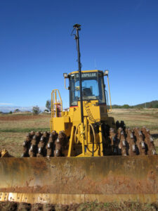
Within the mining sector the use of GPS technology continues to evolve. Primarily used for surveying, machine guidance and positioning, more recently, this has advanced to providing a way of controlling autonomous (driverless) mining equipment such as large haul trucks and drills. (Nitz, 2014).
Similarly within the field of civil construction GPS technologies are transforming the way design engineers, surveyors, contractors, and construction crews execute large and small scale infrastructure projects. Within large scale civil earthworks, tasks which previously had to be done manually can now be completed more efficiently and accurately with GPS based machine control systems. (Caterpillar, 2006)
The use of GPS technology to guide and control earth-moving equipment such as dozers, motor graders, and excavators was quickly adopted in highway construction because it speeds project delivery and cuts costs. It has been demonstrated that productivity with this technology, referred to as “automated machine guidance (AMG)”, can be double that of conventional construction equipment and methods (Caterpillar, 2006).
With the addition of further satellite constellations GLONASS (Russia), Beidou (China) and Galileo (Europe) as well as expansion of ground based continuously operating reference stations (CORS) the applications and uses of Global Navigation Satellite System (GNSS) technologies will continue to expand.
Ongoing research and development is delivering viable solutions for use of the technology indoors (in underground mines and tunnels (ACIL Allen , June 2013B)) and in “urban canyons” in cities and deep open cut mining pits, where “shadowing” of satellite signals limits technology utility. Augmentation of GNSS technology through the use of ground based networks to overcome the problem of signal unavailability is already being used successfully in mines (Rizos, Gambale, & Lilly, October 2013).
The use of GNSS technology increasingly means that production tasks that were once time-intensive, labour-intensive, capital-intensive, and material resource-intensive are able to be streamlined through innovative adaptation of GPS technology to all businesses across the economic spectrum. Productivity gains, input cost reductions, time savings, and environmental, health, and safety benefits are among the various benefits of GPS commercialization. (Pham, 2011)
Economic benefits of precise positioning technologies
“Science and technology have freed humanity from many burdens and given us this new perspective and great power. This power can be used for the good of all.” Jawaharlal (Pandit) Nehru 1889-1964
The advent of the Global Positioning System and its subsequent commercialization has delivered enormous benefits to the U.S. economy (Pham, 2011). Pham calculated that productivity gains and input cost reductions alone due to the use of GPS technologies amounted to between $68 billion and $122 billion per year, or 0.5 to 0.9 percent of annual U.S. gross domestic product.
Similarly, economic modelling by ACIL Allen estimates that output from the construction sector in Australia was between $440 million and $710 million higher in 2012 as a result of the use and application of augmented GNSS technologies in activities such as site surveying and machine guidance. It was noted that with further adoption of GNSS supported applications and expansion of GNSS services this figure could rise to between $1,401 million and $2,469 million by 2020. (ACIL Allen, June 2013A) Drawing on data from the Australian Bureau of Statistics, ACIL Allen noted that total output from the Australian Construction industry in FY2011/2012 was $300 billion and the gross value added contribution of the industry in was approximately $105.7 billion or around 7.9 per cent of total GDP. At the time of the study (August 2012) the Australian construction industry directly employed approximately 977,000 workers. (ACIL Allen, June 2013A)
ACIL Allen similarly estimated that output from the Australian mining sector was between $683 million and $1,085 million higher in 2012 than it would otherwise have been as a result of the use of applications based on augmented GNSS technologies. It was additionally noted that this could rise to between $2,439 million and $3136 million by 2020 with further use of automated mining and related applications. (ACIL Allen, June 2013B).
Pham (2011) noted that 3.3 million jobs in the US were dependent on GPS technology. Of these 130,000 people were directly employed in GPS manufacturing industries, while a further 3.2 million were employed in downstream commercial industries where the use of GPS technologies was intensive. The latter number was expected to grow to more than 5.8 million as the rate of commercial adoption of GPS accelerates.
The rapid adoption of GPS technologies in the United Sates is evident in data compiled by Pham (2011) drawing on research data collated by Dominique Bonte & Stuart Carlaw ABI Research (“Global Navigation Satellite Positioning Solutions 2009”) which shows that revenues from the sale of GPS equipment in the United States increased more than 55 percent in 5 years- from $25.5 billion in 2005 to $39.6 billion in 2010 (average $33.5 billion per year).In this time the number of GPS equipment units sold in North America rose by 75 percent from 69.8 million units to 122.4 million units in 2010.
Figure 1 – Commercial GPS Equipment Revenues in US, 2005-2010
| 2005 | 2006 | 2007 | 2008 | 2009 | 2010 | Grow | |
| Commercial | $4.68 | $6.53 | $8.71 | $9.98 | $9.35 | $10.29 | 120 |
| Ground transport. | 1.20 | 2.14 | 3.47 | 4.23 | 4.08 | 4.21 | 250 |
| Aviation | 0.20 | 0.27 | 0.31 | 0.36 | 0.27 | 0.32 | 56 |
| Machine Control | 0.32 | 0.36 | 0.40 | 0.44 | 0.46 | 0.55 | 72 |
| Marine | 1.65 | 2.35 | 2.97 | 3.25 | 2.76 | 3.25 | 97 |
| People-tracking | 0.01 | 0.01 | 0.01 | 0.01 | 0.03 | 0.06 | 352 |
| Precision | 0.48 | 0.49 | 0.49 | 0.49 | 0.46 | 0.49 | 4 |
| Railway | 0.00 | 0.00 | 0.00 | 0.00 | 0.00 | 0.00 | 0 |
| Surveying/Mapping | 0.51 | 0.56 | 0.67 | 0.73 | 0.70 | 0.83 | 61 |
| Timing/ Synchron. | 0.28 | 0.31 | 0.34 | 0.43 | 0.55 | 0.55 | 97 |
| Non-Commercial | $17.55 | $19.08 | $19.95 | $20.21 | $19.85 | $21.33 | 22 |
| Automobile | 2.16 | 3.89 | 5.05 | 4.92 | 3.82 | 3.58 | 66 |
| Converged | 15.07 | 14.81 | 14.46 | 14.67 | 15.40 | 16.93 | 12 |
| Recreational | 0.30 | 0.37 | 0.44 | 0.61 | 0.61 | 0.80 | 161 |
| Military | $3.24 | $4.25 | $5.28 | $6.44 | $6.12 | $7.98 | 147 |
| Total | $25.47 | $29.87 | $33.95 | $36.64 | $35.33 | $39.61 | 55 |
Table 1 – GPS Equipment Revenues in US by Segment, 2005-2010 (in $ billions)
The non-commercial (consumer) segment, which includes passenger cars, recreational products (handhelds, fitness, and sports hardware solutions), and converged solutions (mobile handsets and portable consumer electronics devices) accounted for nearly 60 percent of total GPS equipment revenues during the period 2005-2010. Revenues generated from non-commercial (consumer) segments increased by 22 percent from $17.6 billion in 2005 to $21.3 billion in 2010.
The military segment increased by 147 percent from $3.2 billion to $8.0 billion in 2010 (Table 1) or 16% of the total market.
Revenues generated from sales to commercial segment users (land transport, aviation, machine control, marine, tracking, agriculture, railways, surveying mapping, timing & synchronisation) increased by 120 percent from $4.7 billion in 2005 to $10.3 billion in 2010, and accounted for nearly 26 percent of total revenues in 2010. The total number of GPS equipment units sold in the commercial segment increased by 305 percent from 1.9 million units in 2005 to 7.7 million units in 2010. Simultaneously between 2005 and 2010, technology advances caused GPS equipment prices to decline, most notably in the commercial segment. On average, the price of commercial GPS equipment declined by 46 percent from $2,454 per unit in 2005 to $1,331 per unit in 2010.
Three industries: precision agriculture, engineering construction and commercial land transportation accounted for approximately 58 percent of total commercial GPS equipment sales in the US.
Agriculture
GPS technology is used extensively in agriculture for what is called precision or site-specific farming. GPS applications are used for farm planning, field mapping, soil sampling, tractor guidance, crop scouting, variable rate applications of seeds, fertilizers, and pesticides, and yield mapping. (Pham, 2011)
Based on an adoption rate of 60% Pham (2011) estimated that the aggregate annual benefits of GPS to crop farming in the USA to be $19.9 billion per year, the equivalent of 11.8 percent of total annual production.
It was noted that as GPS technology improves, the adoption rate will approach and possibly reach 100 percent, raising the potential benefits of current GPS technology to the agricultural industry to $33.2 billion per year, the equivalent of 19.6 percent of the value of current annual U.S. crop production.
Engineering Construction
GPS improves the accuracy and increases the efficiency of many construction functions including town planning, surveying, excavating, grading, sub- grading, transportation, logistics, and work place health and safety. (Pham, 2011)
Based on industry surveys Pham (2011) concluded that GPS adoption rates were about 40 percent in the US heavy and civil engineering construction industry. Using survey data published by the U.S. Bureau of the Census 2007 Pham determined that at a 40 percent adoption rate, GPS technology produces $9.2 billion of cost savings for heavy and civil engineering construction, the equivalent of 3.8 percent of annual production. These savings were calculated to be comprised a $7.6 billion reduction in construction labour costs, a $1.3 billion saving in capital machinery and equipment purchases and hire; and $0.3 billion reduction in affected inputs (fuel & lubricants).
It was noted that the potential benefits of GPS to the industry climb to $23 billion per year, or the equivalent of 9.4 percent of the annual value of the industry, when the adoption rate is 100 percent (Table 2).
Annual Benefits of GPS to US Engineering Construction (Heavy & Civil and Surveying/Mapping) – Table 2:
Commercial Land Transportation
Businesses of all sizes own or lease vehicles to carry out various functions of the companies’ operations. Fleet management and vehicle tracking is one of the fastest-growing applications for GPS technology. It has been shown to increase mobile workforce productivity and safety and enables businesses to reduce labour and fuel expenses. (Pham, 2011)
Studies, surveys, and other industry research reviewed by Pham (2011) indicated that between 50 and 86 percent of all US firms managing vehicle fleets had adopted GPS equipment for that purpose.
Reported average savings attributed to using GPS technology were labour (11.3%), fuel (13.2%), and capital equipment (13.2%) respectively
Based on an estimated fleet management equipment adoption rate of 67.9 percent, and the above savings, Pham (2011) estimated the total annual benefit of GPS equipment to the US to be $10.3 billion, which is 8.1 percent of annual U.S. expenditures on commercial surface transportation activities. The break-down of benefits were: $6.4 billion in labour savings; $1.9 billion in capital savings; and a further $1.9 billion in fuel savings.
Pham (2011) noted that the benefits of GPS to the industry would potentially reach $15.1 billion per year, the equivalent of 12 percent of annual U.S. commercial surface transportation expenditures, when adoption rates reach 100 percent.
In Australia (ACIL Allen , June 2013A) noted that the increasing availability of precise positioning services and machine guidance systems is driving “an ever increasing adoption rate, with large economic benefits being realised by the companies at the forefront” of best industry practice. The expected uptake of the technology within the Australian construction industry up to 2020 is reproduced below.
Specific Benefits of Precise Positioning Technology
“Measure what is measurable, and make measurable what is not so.” Galileo Galilei 1565-1642
GNSS based positioning systems are routinely used for a broad range of commercial applications in the construction sector. Three key segments of the industry with high rates of adoption are Surveying, Machine Guidance and Asset Management. In the future as the interchange of information between precise positioning technologies and modelling software becomes increasingly streamlined, it is highly likely that entire project lifecycles from concept planning, to design and construction and asset management post construction will reside within one 3 dimensional model.
Construction and engineering surveying
Survey is critical to all construction and engineering projects. Survey information is required to support all phases of development from initial planning, through design and construction to the generation of “as built”, quality assurance and asset management information post project completion.
The ability of GNSS technologies to greatly improve both the reliability and efficiency of survey operations through rapid capture of site information; and the fast and reliable set-out of information for design and construction purposes has seen widespread adoption of GNSS technology globally.
Ongoing improvements in GNSS technology have also enabled surveyors to collect and process spatial data more easily enabling significant on-site productivity improvements. (ACIL Allen , June 2013A)
Value to Industry
The productivity benefits derived from GNSS technology use in survey is primarily attributed to reduced labour costs. It has been estimated to account for savings in the Australian mining industry of between 30 to 40 per cent (ACIL Allen, June 2013B). Similar results have been recorded on major infrastructure projects within Australia. The use of precision GNSS technology across the entire project lifecycle for the $625million Sugarloaf Pipeline (Melbourne Water) delivered estimated savings in surveying and set out costs of between 10-20 per cent. (ACIL Allen , June 2013A)
Higher levels of productivity gains have been reported by other studies. A ninety five percent (95%) reduction in surveying labour was observed in a roadway construction test conducted by Caterpillar in Malaga Spain in 2006 (Caterpillar, 2006). Roome & Taylor (2011) similarly observed a 90% reduction in survey time on the A46 motorway project in the UK by being able to download data directly for pavement analysis. While use of GPS technologies in highway construction in the
United States have delivered reductions in survey times in the order of 75% (US Department of Transportation, 2013).
Summary of Benefits of GNSS enabled survey
Machine Guidance
Machine Guidance – is the use of computers, positioning technologies and geospatial models to provide horizontal and vertical guidance to the operators of construction equipment. (US Department of Transportation, 2012).
Machines equipped with automatic machine guidance use GNSS satellites, robotic or virtual total stations, lasers, or combinations of these systems to determine the position of cutting edges or pavement moulds relative to the finished-grade for that location based on an electronic model of the proposed construction site. On board software compares the machine’s position to the design grade at a given location. The control box updates positioning data and sends signals to the hydraulic valves adjusting the cutting edges or pavement moulds automatically for small differences in elevation. Alternatively it will provide the operator with cut or fill amounts via the computer-user interface when there are large differences in elevation (Talend, 2010)
The third and critical component to automated machine guidance is the 3 dimensional model of the project. This software represents the entire project in a digital form and can be used for identifying potential design clashes, earthwork computations, string-less paving, as well as automated machine guidance and control. Combined with machine guidance the project model software improves construction productivity, accuracy and efficiency; reduces costs; and increases safety on the jobsite. Once the job is complete the data from the 3D model can also be used for asset management, maintaining records of materials used, locations of tests, and test results. Future models may include functionality such as schedule and cost accounting simulations (US Department of Transportation, 2012)
Typically in 3D systems, two GNSS antennas are fixed to masts behind the machine and the position of the boom, mast, shovel or bucket is determined via a combination of defined offsets and inertial sensors. Localised base stations are concurrently established and deliver Real Time Kinetic corrections (at high rate) to the operating machines.
Alternatively the contractor may elect to use a Virtual Reference Station in the form of a Continuously Operating Reference Station (CORS) network to supply the correction information. The accuracy of CORS based correction systems (at 30 to 50mm) is typically less than that achieved with localised base stations which generally achieve results in the order of +/- 20mm or better. (ACIL Allen , June 2013A)
With the increasing adoption of GNSS technologies, the use machine guidance is increasingly specified as a contractual obligation in major civil infrastructure projects. Concurrently, the ability to accurately capture spatial data via positioning technologies like GNSS is driving greater utilisation of 3D visualisation particularly during the planning, survey and design phase of projects.
In the future as more CORS network stations are added and GNSS referencing is improved though better communications and improved clock and orbit data products, the accuracy of CORS networks will significantly improve. Additionally as more terrestrial based positioning networks are integrated with GNSS satellite constellations this technology will provide more precise position options for “urban canyon”, indoor, and underground environments such as encountered on tunnel and high rise construction projects in major cities.
Value to Industry
The productivity benefits derived from GNSS technology in Machine Guidance are multifactorial and cumulative. However it is generally the reduction in material double handling that produces the primary saving to any earthworks project.
In 2002, the Journal of Construction Engineering and Management published a study that sought to quantify the productivity benefit of machine control methods over conventional survey and construction. Productivity calculations for conventional versus GPS-guided methods demonstrated machine control productivity increases of 101% for a Caterpillar 140H Grader and 116% for 16H. Grader (Jonasson, Dunston, Ahmed, & Hamilton, 2002).
Caterpillar conducted field trials of Machine Control systems at its facility in Spain in 2006. The resulting report identified a 101 percent productivity gain using automated machine guidance. In that study a dozer, an excavator and a grader equipped with machine control technology were able to complete the road construction test twice as fast; with less than half the number of passes and were two times more accurate than conventional road survey & construction techniques. The biggest productivity gains related to grading and fine grading operations – with a twofold reduction in dozer hours and a threefold reduction in grader hours. This saving was based on one subgrade layer and one base course layer. It was noted that road construction involving more layers would be expected to achieve even greater time savings. Other gains on this project included a 43% saving in fuel consumption as well as improvements in machine efficiency (Caterpillar, 2006)
A simple trench excavation study in Iceland in 2008 comparing the use of conventional and machine guided Caterpillar 330D excavators demonstrated a number of quantifiable productivity benefits. These included 22.93% saving in time to complete excavation, 22.19 % reduction in fuel consumption, 13.65% saving in material excavated, a 59.4% saving in the amount of back-fill material required and a time saving of 57.4% in labour required across the duration of the project. (Aðalsteinsson, 2008)
Vonderohe (2009) cites estimates by the New York State Department of Transport that using 3D models, methods, and GPS-based inspection automation technology can reduce the overall cost of construction staking, inspection, and determination of quantities for road projects by 50%.
Similarly Pham (2011) noted that the use of GPS technologies on construction projects in the US were delivering savings in the order of a 59.8 % reduction in labour (range 57.4 percent to 62.3 percent); a 30% reduction in machinery costs (rental equipment and capital purchase savings in the range of 17.5 percent to 42.5 percent) and fuel savings of 32.4 percent (range from 22.2 to 42.5 percent).
In late 2013, Jas. W. Glover, Ltd a Hawaii based civil contractor successfully used 3D milling and paving controls, to lay 5,000 tons of asphalt per night, in a 12-hour shift compared to the usual 2,000 or 2,500 tons per shift using conventional construction techniques. This enabled the company to complete the reconstruction and resurfacing of one the largest runways in the USA (the Reef Runway in Honolulu 3.6 kilometres long and 60 metres wide) to schedule, avoiding any penalties and liquidated damages of $240,000 per day. Added benefits attributed to the use of GNSS technologies was the achievement of superior surface smoothness and tighter tolerances along the entire length of the runway. (Trimble Heavy Construction Division, 2015)
In Australia, total project savings in the order of 10% are estimated to have been achieved on the $2.5 Billion, 45km, 3 lane Eastlink Freeway project in Melbourne (ACIL Allen , June 2013A). Savings on this project which involved the movement of 7.5million cubic metres of soil, and construction of eighty bridges, seventeen interchanges and 1.6 km three-lane twin tunnels were attributed to a combination of more efficient use of labour and faster completion of tasks. In addition the use of GNSS technologies to more accurately pour 2 million square metres of road subgrade enabled direct project savings of $40 million dollars.
Using three-dimensional Global Positioning System (GPS) machine control and other innovative techniques the Port of Brisbane Motorway Stage 1 project was completed in 2003, six months ahead of schedule (a 30% reduction in time required), with a 10% reduction in total project costs, 10% reduction in traffic management costs and 40% reduction in lost time injuries (Manley, 2004)
More recently Murphy Pipe & Civil (MPC) have used GNSS technology and modified Fockesperger Spiderploughs to install HDPE pipelines up to 630mm diameter for British Gas’s QCLNG project in Australia. Guided by Trimble HYDROpro1 software (for marine applications), the plough enables HDPE pipe to be automatically inserted in a single pass. This installation method enables far quicker pipeline installation compared to traditional methods. In addition as there is no open trench at any time during installation, so risks to people, stock and wildlife are eliminated. Since April 2012, MPC has laid more than 3500+ km of HDPE pipe across QGC’s upstream gas gathering network. (SITECH Construction Systems, 2015)
In the United Kingdom, machine guidance technology was used on the new A46 Newark to Widmerpool motorway which officially opened to traffic on 15 June 2012 (Anon, 2015 A). On this project millimetre GPS2 (mmGPS) equipment was trialled to survey and control the paver and surfacing operations. The use of the system demonstrated repeatable accuracy, compliance with required minimum level tolerances and pavement thicknesses; whilst achieving labour savings of nearly 40 man hours per 500m length of carriageway surfaced. (Roome & Taylor, 2011) (Anon, 2015 B)
Summary of Benefits of GNSS enable Machine Guidance
The primary benefits of precise positioning in supporting machine guidance are:
Asset Management
Asset management is the “coordinated activity of an organization to realize value from assets”. In turn, Assets are defined as: “an item, thing or entity that has potential or actual value to an organization”. (IAM Institute of Asset Management, 2015).
Built Infrastructure
With regards to fixed assets, the use of precise positioning technologies assists not only the construction contractor, but also the corporation or business responsible for the operation and maintenance of the infrastructure post construction. The ability to provide a detailed and accurate spatial description of each asset is a key requirement of modern GIS platforms.
Positional information derived from GNSS based positioning systems is increasingly utilised to identify, record and manage all aspects of asset condition, operations, maintenance, and utilisation over the useful life of the equipment or infrastructure.
In some cases a range of disparate technologies are being integrated to retrospectively capture asset data from older buildings and structures. Recently a combination of Ground Penetrating Radar (GPR), laser scanning and Unmanned Aerial System (UAS) technology was used with GNSS technologies to accurately capture and update underground services, structural and aerial imagery data for a school. (Aptella, 2014 A)
Asset management systems deployed in the infrastructure and construction sectors are critical assisting owners and contractors to effectively manage multimillion dollar mobile and fixed assets.
Mobile Equipment
With regards to mobile assets, the wireless exchange of GNSS enabled electronic information gives fleet managers powerful analytical tools to improve the security, maintenance, utilization, job costing, and productivity of equipment being managed.
In the construction sector, telematics systems are being used to monitor and analyse machine operation and performance (Talend, 2010). Machine data is wirelessly communicated to Web-based networks that enables real-time monitoring of machine productivity. Changes in engine RPM can be used to differentiate machine idling and down time from periods of productivity. Similarly total engine run times can be monitored with notifications set in advance to provide warning of when preventive maintenance needs to be scheduled. Preventative maintenance and servicing at pre- programmed interval assists to prolong asset life and optimise use of labour resources.
Recent advances combining GNSS technologies with the development of site-wide telematics systems are allowing project managers to monitor all machines and rovers on a construction site simultaneously. The system is also capable of relaying real time cut/fill volumes, as well as providing access to machine data and customisable reports on the site’s earthworks progress. (Aptella, 2014 B)
Positional data emanating from these systems can also be used to protect expensive assets and vehicles from theft, loss or unauthorised use. Aside from tracking, these systems can also be used to establish geo-fences which can be used to ensure that machines are not taken outside of a project or mining lease boundary.
Such systems can also be used in Vehicle Management Systems to ensure compliance with a range of corporate and legislated road safety rules. In Vehicle Management Systems (IVMS) are currently used in the Australian oil & gas and mining industries (Securatrak, 2015) to monitor driver behaviours relating to real-time vehicle location, vehicle speed, travel distance, harsh acceleration, harsh braking, impact, roll over, seat belt monitoring, engagement of 4 wheel drive, journey management, trip scheduling, and driver fatigue management. (Intellitrac, 2015). With these systems both management and the operator can be notified when a vehicle is being operated outside of the required parameter.
Value to Industry
The global Asset Management System market is expected to grow at a compound annual growth rate of 20.5% from 2014 to 2020. (Research and Markets , 2014)
With regards to mobile asset management – vehicle tracking is one of the fastest-growing applications for GPS technology in the United States with estimated economic benefits to the value of $10.3 billion per annum. These figures reported by Pham (2011) did not include other benefits attributed to GPS tracking such as a 25 percent increase in work orders (on account of faster completion rates), 45 percent fewer accidents, and 40 percent fewer speeding violations.
Similarly reports from the oil & gas industry indicate that companies that implemented IVMS programs experienced a reduction in motor vehicle crash rates of 49% to 93%; a 60% reduction in speeding events; an 8-20% reduction in vehicle distances travelled; as well as cost savings associated with reduced crashes, fuel consumption and repairs and maintenance (International Association of Oil & Gas Producers , 2014)
In terms of fixed asset management, it is increasingly common on large infrastructure projects for the whole construction project lifecycle to be captured on 3D models which greatly minimise the cost of populating asset management databases once construction is complete.
Summary of Benefits of GNSS enable Fixed Asset Management

Summary of Benefits of GNSS enabled Mobile Asset Management
Conclusion
“We are pragmatists…Does it work? Let’s try it and if it does work, fine, lets continue it. If it doesn’t work, toss it out, try another one.” Lee Kuan Yew (1923-2015) – Interview with the New York Times 2007.
The continued growth of GNSS enabled technology seems assured. The breadth of applications and benefits to be derived from its use in the future will only be limited by our imagination; perseverance to seek new solutions to technological limitations; and collective willingness to invest in ongoing GNSS development and infrastructure. By the end of the decade not only will there be 4 operational Global Navigation Satellite Systems, all transmitting a variety of trackable signals but there could also be a number of Regional Navigation Satellite Systems launched by East or South Asian countries (Japan, Korea, India), with sufficient interoperability with the existing GNSSs systems to contribute extra satellites and signals for use by high accuracy users (Rizos & Satirapod, 2011). Provided issues of compatibility and interoperability between systems are addressed these new systems will provide significantly greater satellite visibility over Asia (and Australia) than is currently available. The likely sum benefit being that the continuity, accuracy, efficiency, availability and reliability of GNSS positioning systems in the region will improve even further (Rizos & Satirapod, 2011). Concurrent with these developments there will need to be further commitment at government level to bring forward the deployment and management of next generation CORS networks to support the increasing demands for precise positioning.
Appendix
SiReNT
The Singapore Satellite Positioning Reference Network, SiReNT is a nation-wide reference network developed to support real-time high precision land surveying and other positioning applications. An initiative by Singapore Land Authority (SLA), SiReNT provides Differential GPS (DGPS) services which supports the latest technology of Network-RTK. http://www.sirent.inlis.gov.sg/
MyGNSSnew CORS – Malaysia
Initially setup by Universiti Teknologi Malaysia-GNSS & Geodynamics Research Group as My ISKANDARnet, this GNSS network was initially comprised 4 stations providing GPS observation data & positioning related services including: GPS RINEX raw data download service; Single-base Real-Time Kinematic (RTK) service; Network-RTK Virtual Reference Station (VRS) service; Differential GPS (DGPS) service; Post-process VRS service. More recently the network has been expanded nationwide as MyGNSSnet (Ruslan, 2014)
References:
ACIL Allen . (June 2013A). Precise positioning services in the construction sector – An estimate of the economic and social benefits of augmented GNSS services in the construction sector. Prepared for Department of Industry, Climate Change, Innovation, Research & Tertiary Education. Sydney: ACIL Allen Consulting Pty Ltd.
ACIL Allen . (June 2013B). Precise poistioning in the mining sector – An estimate of the economic and social benefits of the use of augmented GNSS in the mining sector. Prepared for Department of Industry, Innovation, CLimate Change, Research and Tertiary Education, Commonwealth of Australia. Sydney: ACIL Allen Consulting Pty Ltd.
Aðalsteinsson, D. (2008, May 7). GPS Machine guidance in construction equipment – School of Science & Engineering, Reykjavik University. Retrieved April 03, 2015, from Trimble: http://construction.trimble.com/sites/construction.trimble.com/files/ marketing_material/%20white%20paper%20-%20Productivity%20Report%20GPS%20For%20Excavators%202008.pdf
Anon. (2012, June 20). Machine Guided Productivity -Productivity Savings Using Machine Guidance. Retrieved April 3, 2015, from Machineguidance: http:// www.machineguidance.com.au/cicms/assets/pdfs/pg59as230.pdf
Anon. (2015 A). A46 Newark to Widmerpool Improvement. Retrieved April 03, 2015, from Highways England: http://www.highways.gov.uk/roads/road-projects/a46-newark-to- widmerpool-improvement/
Anon. (2015 B). Resurfacing the A46. Retrieved April 03, 2015, from Institution of Civil Engineers: http://www.ice.org.uk/topics/transport/Case-Studies/Resurfacing-the-A46
Caterpillar. (2006). “Road Construction Production Study.” Malaga Demonstration and Learning Center Spain. Retrieved April 03, 2015, from Trimble: http:// construction.trimble.com/sites/construction.trimble.com/files/marketing_material/ white%20paper%20-%20CAT%20Road%20Construction%202006.pdf
IAM Institute of Asset Management. (2015). What is asset management. Retrieved April 03, 2015, from The Institute of Asset Management : https://theiam.org/what-asset- management
Intellitrac. (2015). Intellitrac GPS IVMS. Retrieved April 03, 2015, from Intellitrac: http:// www.intellitrac.com.au/ImagineGPS-IVMS.html
International Association of Oil & Gas Producers . (2014). Land transportation safety recommended practice – Guidance note 12 – Version 2. International Association of Oil & Gas Producers . International Association of Oil & Gas Producers .
Jarosz, A. P., & Finlayson, R. (2003). GPS Guidance System and Reduction of Open Pit Mining Costs and Revenue Loss. Paper presented at the Spat?al Sc?ences, Inaugural Conference of Spatial Sciences Institute, (p. 13). Canberra, ACT, Australia.
Jonasson, S., Dunston, P. S., Ahmed, K., & Hamilton, J. (2002). Factors in Productivity and unit cost for advanced machine guidance. Journal of Construction Engineering & Management, Vol.128,(No 5,), pp. 367–374.
Manley, K. (2004). Motorway Alliance Drives Performance Improvement – Innovation Case Study Number 3. Retrieved April 03, 2015, from Queensland University of Technology Digital Repository: http://eprints.qut.edu.au/27109/1/27109.pdf
Nitz, J. (2014). High-Precision GPS Applications in Open Pit Mining – Research Project Thesis – Master of Mining Engineering. Ballarat Victoria Australia: School of Science, Information Technology and Engineering, University of Ballarat.
Pham, N. P. (2011, June). The Economic Benefits of Commercial GPS Use in the U.S. and The Costs of Potential Disruption. Washington DC: NDP Consulting Group.
Position Parners. (2014 A, May 12). Facilities Management made eady. Retrieved April 03, 2015, from Aptella: http://www.aptella.com/news/position- partners/facilities-management-made-easy/
Aptella . (2013, January 29). Manage your machines. Manage your mine. Retrieved April 03, 2015, from Aptella : http://www.aptella.com/ products/mining/material-management/carlson-fleet-manager-office.htm
Aptella. (2014 B, June 25). Link to Machine Control Productivity. Retrieved April 03, 2015, from Aptella: http://www.aptella.com/news/position- partners/link-to-machine-control-productivity/
Research and Markets . (2014, November). Asset Management System Market by Function, Asset Type, Technology, Industry, & Geography – Analysis & Forecast to 2014 – 2020. Retrieved April 03, 2015, from Research And Markets: http:// www.researchandmarkets.com/research/jtwbl7/asset_management
Rice, C. (2014, February 15). GPS: From launch to everyday life. Retrieved April 03, 2015, from BBC New Technology: http://www.bbc.com/news/technology-26153506
Rizos, C., & Satirapod, C. (2011). Contribution of GNSS CORS Infrastructure to the Mission of Modern Geodesy and Status of GNSS CORS in Thailand. Engineering Journal 15(1), 25-42.
Rizos, C., Gambale, N., & Lilly, B. (October 2013). Synchronized Ground Networks Usher in Next-Gen GNSS. GPS World, Pg 36-41.
Roome, B., & Taylor, P. (2011, November 15). A46 Newark to Widmerpool Improvement – Joint ICE / CIHT / ICES Meeting. Retrieved April 03, 2015, from The Chartered Institution of Highways & Transportation: http://www.ciht.org.uk/download.cfm/docid/
5D2D2FC5-887E-4B4F-B583FDC1B4F900EF
Ruslan, A. (2014). GNSS/GPS continuously operating system (CORS) IN Malaysia. GNSS Summer School 2014 (pp. http://www.gnss-pnt.org/SummerSchool2014/workshop/6.pdf). Tokyo Japan: Tokyo University of Maine Science and Technology (TUMSAT) and The Institute of Positioning, Navigation and Timing of Japan.
Securatrak. (2015). Mining Oil & Gas – Advanced GPS Vehicle Tracking Solutions. Retrieved April 03, 2015, from Securatrak: http://www.securatrak.com.au/Industries/Mining-Oil- Gas
SiReNT – Singapore Satelitte Positioning Reference Network. (2015). Retrieved April 03, 2015, from Singapore Land Authority: http://www.sirent.inlis.gov.sg/
SITECH Construction Systems. (2015, February). Innovate, Excavate, Repeat: The QGC Pipeline Project. Retrieved April 3, 2015, from Machineguidance: http:// www.machineguidance.com.au/Innovate-Excavate-Repeat
Talend, D. (2010, Spring). GNSS and profitable heavy equipment utilization. (M. Tennis, Ed.) Construction Superintendent, pp. 16-17.
Trimble Heavy Construction Division. (2015, Jan). Machine Guided Runway Reconstruction. Retrieved April 03, 2015, from Machineguidance: http:// www.machineguidance.com.au/cicms/assets/pdfs/pg100as230.pdf
US Department of Transportation. (2012, September). 3D Modeling for Construction – Participant Workbook Part 1 . Retrieved April 03, 2015, from US Department of Transportation Federal Highways Administration: www.fhwa.dot.gov/accelerating/ presentations/3d/3d-work_1.pdf
US Department of Transportation. (2013). Automated machine guidance with the use of 3D models – FHWA-HIF-13-054. Retrieved April 03, 2015, from US Department of Transportation Federal Highway Administration Tech Briefs: http://www.fhwa.dot.gov/ construction/pubs/hif13054.pdf
US Department of Transportation. (2014). Automated Machine Guidance with Use of 3D Models – Case Study – The use of automated machine guidance on the Florida SR 417 lane widening project – FHWA-HIF-13-055 Techbrief. Retrieved April 03, 2015, from US Department of Transportation Federal Highway Administration Tech Briefs: http:// www.fhwa.dot.gov/construction/3d/amg/pubs/hif13055.pdf
Vonderohe, A. P. (2009). Status and Plans for Implementing 3D Technologies for Design and Construction in Wisconsin Department of Transportation- Final Report – Project ID: WisDOT 0657-45-11 CMSC 2008 – WO 2.6. Construction and Materials Support Center University of Wisconsin – Madison – Department of Civil and Environmental Engineering.