Drones are essentially an aircraft that doesn’t have a human pilot onboard, instead, they are controlled by an autonomous onboard computer or an operator who is stationed on land. It is also common for most surveying UAV (unmanned aerial vehicle) drones to be equipped with VTOL (vertical take-off and landing) capabilities – as a matter of course in 2020.
We distinguish some drones used for aerial surveying as VTOL and some as standard UAV. It is important to note that all drones are UAVs but not all drones have VTOL. VTOL drones work in a series of steps:
1) Aerial mapping drones with VTOL capabilities start with firm placement on the ground and proceed to soar vertically into the air using their rotors. No piloting skills are necessary during this take off as it is fully automated – but certification from Australia’s Civil Aviation Safety Authority is necessary for VTOL drones over 2kg.
2) VTOL drones are easier for the operator and less complicated during the launching process (as compared to traditional methods such as a catapult-launch or manual launching by throwing).
3)Once in the air, the VTOL survey drone tilts its rotors horizontally and travels forward like an aeroplane in flight mode with a fast airspeed.
4)The VTOL drones rotors then tilt vertically again to finish the desired flight route. The drone autonomously lands on the ground in the same place where it started in a vertical position.
5) This process is all handled by the land-based operator using a control panel on an iPad, Toughpad or even a mobile phone application.
On the other hand, standard UAV drones use operators who typically throw the drones into the air or use a land-based catapult system. This method is effective but out-dated which has some inherent safety issues and risks to the operator or the surrounding environment. The drone itself will be more prone to damage causing the need for costly repairs or replacement. VTOL is an amazing advancement in the launching and flying of professional survey drones.
When a person refers to the ‘payload of drones’, they are referring to two things – firstly to the amount of camera weight or additional survey technology that a single drone can carry within its lifting limits and capability. Secondly – and more specifically to the survey and geospatial industry, we are referring to the quality of the sensor that is being lifted into the air for the purposes of geospatial mapping or photogrammetric surveying.
Each specific drone brand and type has varying payload capacities including a difference between VTOL and standard UAV. Standard fixed-wing drones land flat with an average-sized camera attached which also faces the ground to take images. The camera is then left vulnerable to abrasion, dust and dirt from rough terrain. However, drones with vertical landing ensure that the expensive cameras and sensors affixed to the underside of the drone never come into contact with the ground.
So, in the surveyor community – the ‘payload’ of a drone refers to the type of survey-capable equipment that the drone is lifting – meaning the quality of the camera (usually expressed in megapixels), the laser scanner or Lidar attachment, the multi-spectral sensor or thermal sensor. A payload is, therefore, an expression related to the surveying capabilities of a drone more so than the weight (which is still related, don’t worry!).
When it comes to the weight of a payload – there is a term called ‘all up weight’ or AUW – which is the total carrying capacity of the drone that is clearly expressed in the specifications of the drone prior to purchase. And while the sensor is the most important fixture of a drone for surveying applications, the AUW can include the weight of the battery powering the drone and the survey equipment, the data management features (such as the onboard storage of the thousands of high-resolution images that are being taken by the drone every second) and the RTK technology that gives the drone a relative position using GPS.
When we look at the industry standard VTOL survey drone, there is an obvious correlation between the size and carrying capacity of a drone, a larger payload and higher survey accuracy. A larger drone also has the capacity to carry high-end cameras, sensors and LiDAR equipment for accurate aerial mapping. The multi-rotor drones carry the lightest payloads in the industry – but even the entry-level payload offered by Aptella at approximately 2kg can give hyper-accurate photogrammetric survey images across a large expanse – that are suitably precise for the purposes of most aerial surveying. Fixed-wing drones are capable of carrying a larger payload than multi-rotor drones, with some single rotor drones capable of carrying a payload of up to 50kg.
Aptella RPAS – Our VTOL Offering and Payload Options
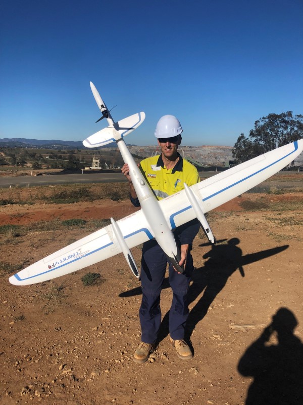
The Aptella range of survey drones includes our VTOL drone offerings and camera payload options. We offer three main VTOL drones – Trinity F90+ VTOL RPAS, DJI Matrice 300 RTK and DJI Phantom 4 RTK.
1) Trinity F90+ VTOL RPAS drone: This Trinity VTOL aircraft has a flight time of approximately 90 minutes with the MicaSense dual camera, Sony RX1R II camera, Sony UMC-R10C camera, RedEdge-MX sensor and MicaSense Altum sensor as the payload options.
2) DJI Matrice 210 RTK V2 drone: This DJI Matrice drone ensures flight stability and reliability to provide survey-grade accuracy. With multiple payload options available, the drones centre of gravity can be calibrated for the best flight performance.
3) DJI Phantom 4 RTK drone: This DJI Phantom aircraft is proclaimed as the next generation of mapping technology for drone accuracy. This drone weighs 2 kilograms with a smaller payload – mostly suitable for small to medium aerial mapping applications.
We source, deploy and support intelligent positioning solutions to enhance our customers’ productivity.
Aptella Pty Ltd
ABN 56 130 367 065
2024 Aptella Pty Ltd | ABN 56 130 367 065 | Terms and Conditions | Privacy Policy