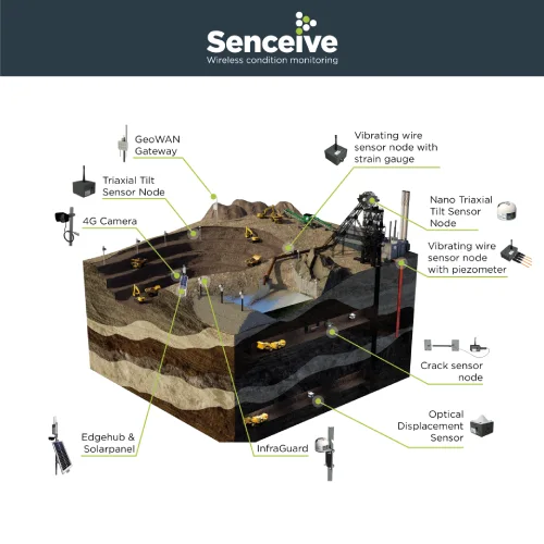
Senceive GeoWAN

Where a geotechnical or structural monitoring solution is required to cover a large area, such as a mine or a city, we would usually recommend our GeoWAN communication platform.

  • Tunnels and pipelines
  • Dams, mines and quarries
  • Covered or obstructed assets and open areas or congested urban environments
  • Buried or subsurface structures e.g. basements
  • Highly dispersed asset monitoring
Request more information about this product
Categories:

Description

GeoWAN uses a lower frequency radio band than FlatMesh. It is based on the industry-standard LoRaWAN protocol and is capable of long-range transmission with sensors able to communicate with a gateway at a distance as great as 15 km.

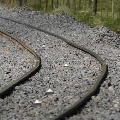
Monitoring systems using GeoWAN have the power to transmit through physical obstructions, enabling, for example, integration of sensors in boreholes or on buildings above a tunnel with movement sensors measuring deformation inside the tunnel.

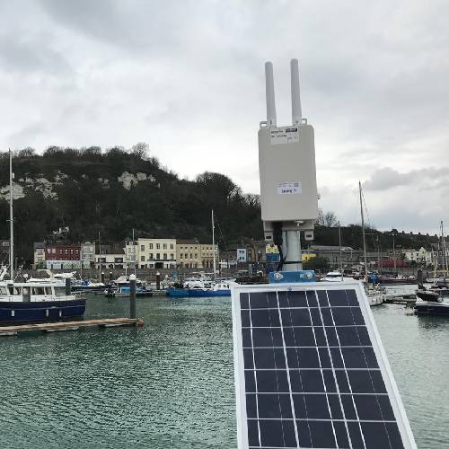
From the gateway the options for getting the data to the outside world are restricted only by the available infrastructure. The simplest option in most cases is to use the gateway’s integrated cellular (2G/3G/4G) modem; alternatively, the gateway’s Ethernet connection may be used to enable connectivity via WiFi, ADSL or cable connections.

Features

  • Full range of wireless geotechnical/ structural sensors
  • 4 km range in urban environments
  • Maximum range of 15 km in optimal conditions
  • Waterproof to IP66/68
  • Up to 15 years battery life on nodes
  • Flexible gateway options
  • Seamless roaming across gateways for ultimate system redundancy

Specifications

GeoWAN Radio Specifications

Parameter Value
Communication Type Star Topology
Frequency Band 863 MHz – 928 MHz ISM Band
Maximum Transmit Power 20dBm (actual transmit power depends on geography)
Range Up to 15 km depending on the environment
Maximum Reporting Frequency 30 Seconds

Flatmesh or GeoWAN?


FlatMesh™ GeoWAN™
Third generation intelligent flexible mesh network monitoring platform/architecture Long-range point to point wireless platform, ideal for challenging environments; capable of “seeing through” solid obstructions
Up to 300 m range (gateway to node or node to node), in optimum conditions Up to 15 km range (gateway to node), in optimum conditions and typically 2-4 km in busier urban environments
Battery life of up to 15 years Battery life of up to 15 years
  • Best for dense wireless sensor node deployments
  • Standard reporting rate: 10 minutes
  • Standard reporting rate: 1 hour
  • Number of nodes in network will affect speed of reporting rates
Fully remotely configurable Remotely configurable, but more limited bandwidth available
  • Available with intelligent and triggered sampling rates based on real movement of sensors to minimise human intervention
  • Can function as Intelligent Solution with multiple structural and geotechnical sensor types and integrated 4G cameras
  • No triggered sensing from other nodes in the network
Compatible with full range of geotechnical and structural sensors Compatible with full range of geotechnical and structural sensors
Ideal Applications:

  • Tunnels
  • Rail trackbed
  • Bridges, walls, piles, structures
  • Geotechnical earthworks and soil water content measurement
Ideal Applications:

  • Congested urban environments including busy construction sites
  • Long-range applications with sensors dispersed across wide areas, such as mines and quarries
  • Applications where communication is needed through obstructions such as buildings or the ground such as underground structures
  • Sites where mains power is available

Downloads

Brochure Flatmes/GeoWAN Tunnel Monitoring

Video

Watch to find out more

1 review for Senceive GeoWAN

  1. Callum McNaughton

    The wireless monitoring platform has been perfect for us. It dramatically reduces the need for us to manually survey these areas, saving us time and increasing safety by removing surveyors walking these areas on foot.

Add a review

Your email address will not be published. Required fields are marked *