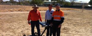
(From L-R: Frank Norton, Michael Wanrooy and Stuart Brown)
Approximately four hours’ drive east of Mt. Isa lies the small town of Richmond in Queensland. On the western edge of town sits the Pioneer Cemetery, the final resting place for some 300 early Australian settlers according to Richmond Shire Council records. However these days only 35 or so headstones and grave markers are still standing and it is thought some of these may be placed inaccurately.
Members of the community and the Council were eager to locate the remaining plots without disrupting the area with excavations. There was concern that many of the burial sites could lie outside the boundaries of the cemetery and perhaps under a carpark which was built along with a perimeter fence some 10 years ago.
The Council hired a Ground Penetrating Radar solution from Aptella to enable them to accurately scan underground and locate additional burial sites.
Stuart Brown, Construction Sales Consultant for Aptella, travelled to the site to assist the council conduct the scan.
“Using the US Radar Q5C GPR, we conducted a series of single scans and one 3D scan covering approximately 240 square metres of the car park,” he said. “In six hours, we had identified at least 20 additional burial plots, a sewer main and potentially another main line for the town.”
Although there was additional work to be done to map the surrounding area and locate the remaining burial sites, Mr Brown said the initial results were encouraging. “The GPR enables you to find the information you need very quickly, without any disruption to the site. It took six hours to collect the data and a further seven to analyse it and generate reports, so in a few more days we could map the entire area and give these early Australians a proper resting place.”